LLANDOVERY ANGLING ASSOCIATION
Salmon, Sea Trout / Sewin & Wild Brown Trout Fishing, River Towy, Wales


WHERE TO FISH >>
Click here for a comprehensive Google map of the Lower Water and Upper Water
Llandovery Angling association runs two fisheries on the Towy above and below Llandovery
Upper Towy Fishing above Llandovery town including the newly aquired fishing at Bwlchnewydd, Rhandirmwyn.
The general character of the river is very different to the water below the town. The upper river channel is predominantly narrower, and runs through rock faced gorges interspersed by deep holding pools. Some pools such as Dolauhirion, Tairheol and Divlyn are famous for their past reputations of holding large numbers of Salmon and sewin. Unchanged for centuries these lies that the fish favour, have deep ledges and channels with a gravel bottom. For the solitary angler such waters can be very exciting to explore, working upstream with a running worm or an enticing spinner.
Anything from a fresh run grilse to a ten pound sewin is a possibility. Large pike also lurk in the deep murky pools but it is also possible to fish the tails and gravel runs for brown trout with a fly rod. Because there are no major obstacles to prevent fish running from the sea to the upper Towy in little more than twenty four hours, sewin can be caught as early as May. However fish are more numerous in the months of July and August. Later in the season would also offer a better opportunity of catching a salmon. The Association fishing extends to over seven miles above Llandovery, at least half of which is double bank. There is easy access to the river from the Llandovery to Rhandirmwyn road.


Lower Water below the town of Llandovery (including the farms of Llwynjack, Glantowy and Cwmgwyn)
This beat extends to over three miles of double bank fishing starting just below the chain bridge below the town, and ending down stream at Cwmgwyn Farm. There is easy access to the river from several locations which are well signposted along the A4069 road to Llangadog as indicated on the map.
This reach of river could be described as classic fly fishing water for sewin which is easily covered with a single handed fishing rod..
The River now meanders through rich meadows and is supplemented by the additional volume of water from a major tributary the River Bran.
The beat contains several deep holding pools interspersed by productive runs and riffles. The river bank has plenty of vegetation to provide cover for resting fish, but there is ample room for casting and the wading is easy and safe over the clean gravel river bed.
During a wet spring large sewin can be caught. Late April and May can be very good months, when fish well in excess of ten pounds are caught. The main run of sewin often averaging four to five pounds usually appear from the middle of June onwards. July, August and September can be good for the smaller shoal sewin and salmon become more numerous as the season progresses.
Please note that the end of fishing on the lower water is indicated by a sign on the right hand bank looking downstream below the bottom pool. Every effort is made to ensure that the maps on the site are accurate. However if you have any queries please email us here
Click on maps for downloadable PDFs
Middle Pool (Lower Water)

Rock Pool- Lower Water


Boulders-Lower Water

The Bushes (Lower Water)

Bottom Pool (Cwmgwyn)

Bottom Pool (Cwmgwyn)

Tributaries- Bran and Gwydderug
Trout fishing is available on these two spate streams where even a small rise in level can tempt the resident trout out of the shadows to feed and where light tackle is the order of the day. The riverbank is a combination of tree cover, where a small spinner flicked under the overhanging branches would be best and open areas ideal for stalking with a short fly rod and lightweight line.


For a Google map of these fisheries and information on parking, boundary limits and where to fish, click Here. Click on individual map icons to reveal description of Beats, boundary limits, access and parking.
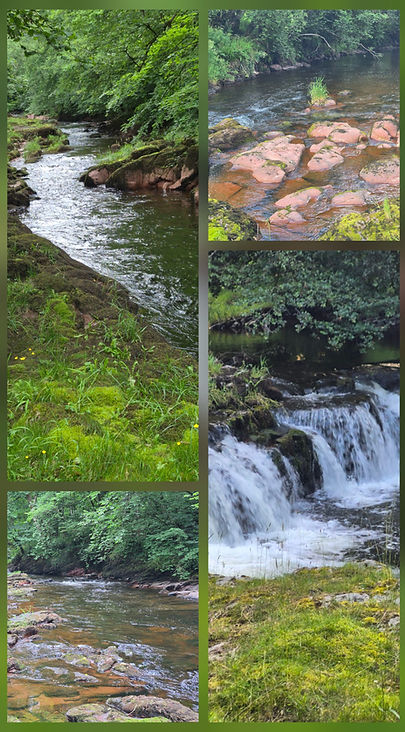
River Usk - Pantyscallog
Predominantly flowing over a bedrock of Red Sandstone, this beautiful and secluded beat covers one mile of right bank fishing on the River Usk . The river here is small to medium sized and includes a waterfall at the upper end of the beat and a mixture of pools, fast runs, flats and deep gutters throughout. In compliance with Usk policy, this remains a Fly Only Beat and although running between steep, wooded banks, casting a fly is possible throughout most of the beat with only a short cast required and the fast flowing runs and deep gutters are ideal for Euro Nymphing . For Dry Fly an 8.6ft rod is ideal. Red Sandstone is notoriously slippery when wet, so Felt Soles are recommended for wading.
Note: This beat is not available on a Day or Week Permit

The Upper Boundary is at the confluence with its tributary the River Crai and the Lower Boundary is marked by a fallen tree across the river.
Access from the A40 is via a narrow road with a width limit of 6ft 6ins. Once over the bridge, parking for 2 cars is available either side of the wooden gate on the left.
Access to the river must only be through the small metal gate on the left, just inside the field and either walking under the bridge to reach the upper water or following the path along the bank to fish downstream.

The riverbank itself is mostly lichen covered rock and easy to fish from, so wading is rarely necessary.
This is an excellent opportunity for members to experience Wild Fishing at its best. The Usk is noted for holding large trout with fish up to 4Lb not uncommon.